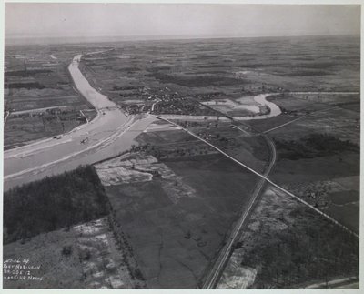
Old Bridge 12 on the Welland Ship Canal at Port Robinson
Description
- Médias
- Image
- Type d'élément
- Photographs
- Description
- A photograph of Old Bridge 12 on the Welland Ship Canal (Fourth) at Port Robinson looking north. April 1930.
- Notes
- File Location: Case, SPEC COLL 386.47 WEL (Welland Ship Canal: Aerial Views Showing Canal From Port Weller to Port Colborne)
The bridge was replaced by a vertical lift bridge. That bridge was destroyed when the ship "Steelton" crashed into it in 1974. It was never replaced and a ferry operates in its place.
The image is part of a scrapbook containing aerial photographs of the Welland Ship Canal (fourth) from Port Weller to Port Colborne. - Inscriptions
- Port Robinson Bridge 12 Looking North
- Date
- 1930
- Dimensions
-
Largeur: 22.1 cm
Hauteur: 17.7 cm
- Dimensions d'image
-
Largeur d'image: 21.5cm
Hauteur d'image: 17.15cm
- Sujet(s)
- Langage de l'élément
- English
- Couverture géographique
-
-
Ontario, Canada
Latitude: 43.039143558701 Longitude: -79.2124116879272
-
- Déclaration de droit d'auteur
- Copyright status unknown. Responsibility for determining the copyright status and any use rests exclusively with the user.
- Contacter
- St. Catharines Public LibraryCourriel:info@myscpl.ca
Adresse Internet:
Adresse postale d'agence54 Church St.
St. Catharines, ON L2R7K2
905-688-6103