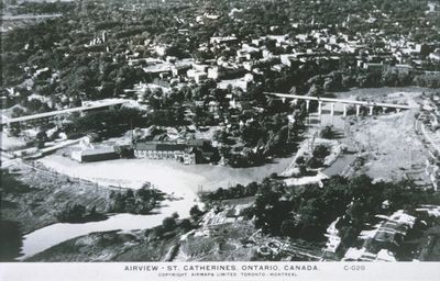
An Aerial View of the Old Canal and Lock 3
Description
- Creator
- A. H. Tiplin
- Media Type
- Image
- Item Type
- Slides
- Description
- An aerial view of downtown St. Catharines and the second Welland Canal, St. Catharines, Ontario. Date Unknown.
Lock 3 and the Glendale Bridge can be seen in the right side of the image.
Kinleith Paper Company can be seen between the Burgoyne Bridge and the Glenridge Bridge. - Notes
- File Location: CASE Welland Canal Slides 19
Kinleith Paper Co. was incorporated in 1899. It was located below the Burgoyne Bridge on the east bank of the 12 Mile Creek. On August 13, 1904 a rag boiler blew up destroying part of the mill. Kinleith remained in business until the late 1920s. In 1939 it became the site of Lincoln Foundry. The site remained until it was demolished for the new 406 project. - Inscriptions
- Airview - St. Catharines, Ontario, Canada.
- Subject(s)
- Language of Item
- English
- Geographic Coverage
-
-
Ontario, Canada
Latitude: 43.1530986445172 Longitude: -79.2437435131836
-
- Copyright Statement
- Copyright status unknown. Responsibility for determining the copyright status and any use rests exclusively with the user.
- Contact
- St. Catharines Public LibraryEmail:info@myscpl.ca
Website:
Agency street/mail address:54 Church St.
St. Catharines, ON L2R7K2
905-688-6103

